Hotels at Texel Hotels at Texel booking.com

accommodation Texel next accommodation island Vlieland

Booking.com

island accommodation: Hotel ,Holiday Home, Camping

Hotel at Texel ?> Hotel Hotel at Texel booking.com
Campings at Texel ?> Camping 1) De Bremakker
2) De Koorn-aar
3) De Luwe Boshoek
4) De Robbenjager
5) Landal Sluftervallei
6) ’t Woutershok
7) Texelcamping De Shelter/Om de Noord
8) Texelcamping Kogerstrand
9) Texelcamping Loodsmansduin
10) Vakantiepark De Krim Texel
Holiday Home
Bed & Breakfast
accommodation-page Texel

Naming - Location

Local native name: Texel
Archipelago (island group): Wadden Islands
Neighboring islands
(Island hopping):
1) Noorderhaaks - De razende bol 1.1 km SouthWest
2) Vlieland 2.6 km North
3) Richel 20.3 km NorthEast
4) Griend 25.6 km EastNorthEast
5) Terschelling 27.2 km NorthEast
6) Ameland 57.7 km EastNorthEast
7) Pampus 72.7 km SouthSouthEast
8) Het Rif 83.6 km EastNorthEast
9) Engelsmanplaat 83.6 km EastNorthEast
10) Schiermonnikoog 88.8 km EastNorthEast
11) Zuidelijke Ballastplaat 88.9 km EastNorthEast
12) Robinson Crusoë 90.7 km SouthSouthEast
13) Markus Pos 91.2 km SouthSouthEast
14) Geitekaai 91.5 km SouthSouthEast
15) Meent 92.6 km SouthSouthEast
16) Simonszand 108 km EastNorthEast
17) Rottumerplaat 112.4 km EastNorthEast
18) Rottumeroog 119 km EastNorthEast
19) Zuiderduintjes 119.5 km EastNorthEast
20) Middenplaat 125.2 km SouthSouthWest
21) Borkum 126.7 km EastNorthEast
22) Slijkplaat 137 km SouthSouthWest
23) Rietplaat 137.4 km South
24) Buisjes 137.5 km South
25) Hennipje 138.1 km South
Country: The Netherlands
Location in Country: North-northwest
Name Provincie: Province North Holland
Name Gemeente: Municipality Texel
Main place: Den Burg
Places portal2europe
(sister website):
De Cocksdorp (NorthNorthEast)
De Koog
De Waal (Central)
Den Burg (Central)
Den Hoorn (SouthWest)
Midden-Eierland (NorthEast)
Oost (EastNorthEast)
Oosterend (Central)
Oudeschild (SouthSouthEast)
't Horntje (SouthSouthWest)
Zevenhuizen (Central)
Zuid-Eierland (Central)

Location Main place: Center
Sea: Wadden Sea
Distance to main land: 2.5 km
Nearest Country: The Netherlands
Type Rock outcrop: sand
island-Type: island in sea
Remarks: Texel is the largest Dutch Wadden Island and relatively close to the mainland (Den Helder). Due to the All Saints' Flood of 1170 it became an island (formation of the Marsdiep) just like Vlieland. In the seventeenth century, the more northerly island Eierland was added to Texel by means of a sand dike. At the end of the Second World War, Texel was the scene of Europe's last battlefield.


Topographic map island accommodation Texel
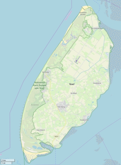
Texel map

© OpenStreetMap-auteurs, CC-BY-SA.

accommodation Texel views: 1411

4 starsaverage score: 4 from 4 votes.


island-Sights, island-Tourism - island-attractions

Wikipedia Texel ?> Wikipedia: Wikipedia Texel
Tourist information: Info Texel
Youtube: Youtube Texel
UNESCO Texel ?> UNESCO: The Wadden Sea


Social media - Multimedia

Youtube Video TexelVideos youtube Texel
flickr pictures and images of TexelPhotos (Flickr) of the place Texel


Bings maps Texel
Mapquest Texel
Loc.Alize.us Texel